Marknadens största urval
Snabb leverans

Böcker utgivna av Arcadia Publishing Library Editions

Filter
Filter
Sortera efterSortera Populära
  • av Karin L Stanford & Institute for the Arts and Media
    385,-

  • av Eads High School Local History Project & Kiowa County Historical Society
    359,-

  • av Dave Crimmen
    385,-

    Broadmoor Village, the little community that embodies the American ethic of independence, survives despite neighboring annexations, budget crises, and even Mother Nature. This subdivision was built in San Mateo County by the Stoneson Company just after World War II, targeting returning veterans and their families. Established before Henry Doelger made neighboring Westlake, Westmoor, St. Francis, and other communities since annexed by Daly City, Broadmoor has repeatedly chosen to stay unincorporated and independent. This attitude has shaped Broadmoor through the years to assert its autonomous stature while surrounded by larger cities.

  • av Marc Wanamaker & E J Stephens
    359,-

    Since 1928, Warner Bros. has produced thousands of beloved films and television shows at the studio's magical 110-acre film factory in Burbank. This collection of evocative images concentrates on the Warner Bros. legacy from the 1920s to the 1950s, when timeless classics such as Casablanca, The Maltese Falcon, and East of Eden came to life. It also looks at WB's earlier homes along Hollywood's "Poverty Row," the birthplace of Looney Tunes, and the site of WB's pioneering marriage between film and sound in the 1920s. Early Warner Bros. Studios also tells the tale of four brothers--Harry, Albert, Sam, and Jack Warner--scions of a Polish Jewish immigrant family who rose from the humblest of origins to become Hollywood moguls of enormous and lasting influence.

  • av Carson Hendricks
    385,-

    Starting in San Francisco in 1854, the California State Fair and Exposition began as a vehicle to showcase, encourage, and expand California's agricultural industry. It quickly became an attraction for thousands of residents, both local and from across the state. By 1884, it occupied the largest exhibit hall in the United States. Within 100 years, it became the largest fair in the country by adding horse racing, elaborate exhibits from every county in the state and from around the world, thrill rides, top-flight entertainment, and, of course, the best food. The original goal of the fair was met some 50 years ago, as California remains the nation's top producer of agricultural products.

  • av Shirley Nelson
    385,-

    Perched on the cliffs above the Pacific Ocean, Port Orford claims to be the oldest town site on the Oregon coast and the farthest west incorporated community in the continental United States. Incomparable scenery surrounds it, providing work for generations of residents: lumber from trees of the great forests and all manner of seafood harvested from ocean waters. Gold lay in the waters and banks of streams and in the black sands of beaches, attracting the earliest settlers in 1851. Farming came later but proved successful, especially for cattle and sheep farmers and cranberry growers. Residents have survived fire, earthquake, severe storms, and the fluctuations of the mining, timber, and fishing industries. As Oregon developed, county lines changed. The south coast area was part of Jackson County in 1852, then Coos County in 1853. Curry County was formed in 1855, and Port Orford was the first county seat until Oregon statehood in 1859.

  • av Norm Hammond, M D Austin & M D Linda
    359,-

    Oceano is a California beach town between San Francisco and Los Angeles. Originally part of the Rancho El Pismo Mexican land grant of 1840, Oceano first appeared as a place name on a map in 1893 and was promoted as a beach resort soon after the Southern Pacific Railroad arrived in 1895. While most of these promotions failed during the Great Depression, the railroad depot continued as a shipping point for the area's agriculture. During this time, Oceano became a point of entry for the "Dunites," a group of artists, writers, and poets who once lived in the sand dunes south of town. Today Oceano is still the primary access and gateway to its state park beach and large sand dune complex. Many people come to enjoy the experience of driving on the beach, camping there, and venturing into the dunes on foot or by vehicle.

  • av Kathy Heicher & Eagle County Historical Society
    385,-

    Nestled into a scenic mountain valley at the junction of the Eagle River and Brush Creek, Eagle is a small mountain town that is often overshadowed by its famous ski resort neighbor, Vail. However, this thriving little mountain community claims a rich history of more than 100 years of spunk and fortitude. Eagle's robust character started with the miners who came to the valley in the 1880s seeking gold and silver. Then came the farmers and ranchers, who recognized another type of wealth in the fertile soils and abundant water of the valley. As for that spunk, the townspeople of Eagle were tenacious enough to wage a 20-year war seeking county seat status and progressive enough to keep a small town growing and thriving for over a century.

  • av Don Peterson & The History Museum
    359,-

    Before Meriwether Lewis saw the Great Falls of the Missouri River in 1805, the area had been visited for centuries by plains bison and the Blackfeet Indians. The city's founding father, Paris Gibson, learned of the falls from Lewis and Clark's journals, and with financing from railroader James J. Hill, Gibson began building the city of Great Falls in 1884, capitalizing on its Missouri River location. After the railroad arrived, the first of five hydroelectric dams was built, along with smelters for silver and copper. The year 1909 saw the homestead boom and settlers by the thousands, while World War II's construction boom supported large military facilities in the city. Great Falls' good times lasted 90 years.

  • av Sybil Barnes
    359,-

    Estes Park is a small village nestled in the north central mountains of Colorado. The earliest settlers were homesteaders who arrived to "prove up" in the 1870s and soon discovered that providing lodging and entertainment for outdoor adventurers and tourists looking for a respite from city life could provide a more reliable revenue stream than farming and ranching. By 1905, the town was platted and several hotels provided modern accommodations. When Rocky Mountain National Park was created in 1915, Estes Park became the eastern gateway and continues to be the first stop for approximately 2.5 million visitors annually. From an initial population of less than 200, the town has grown to almost 10,000 year-round residents, many of whom still make their living providing goods and services to visitors from as near as Denver and as far away as Nepal.

  • av Cory Graff & Puget Sound Navy Museum
    385,-

    Even before settlers came to the Puget Sound, the U.S. Navy was exploring the sheltered inlets and deep water ports of what was dubbed "America's Mediterranean." In 1856, the sailors of the navy warship Decatur repelled an attack by Native Americans, saving a tiny village on the shores of Elliott Bay named Seattle. In the ensuing years, Puget Sound became the West Coast's premier port of call for the navy's vessels and aircraft operating in the vast Pacific Ocean. During World War II, the region turned out a long line of combat and support vessels while quickly repairing many other ships that had been horribly damaged in clashes with the Japanese. In both peace and war, the communities of Puget Sound and the U.S. Navy have shared an enduring partnership that remains today.

  • av Christian Gelzer & Ted Huetter
    359,-

    Known for more "first flights" and record flights than any other place, Edwards Air Force Base is legendary. Centered around an ancient dry lakebed in the Mojave Desert 90 miles north of Los Angeles, activity at Edwards has sharpened the cutting edge of aviation and aerospace since the 1940s. The complex is a strategic flight test, research, and development center for the U.S. Air Force, NASA, and civilian contractors. Since the 1950s, almost every U.S. military aircraft has been partially tested here. The skies above Edwards have been the scene of remarkable achievements, including Chuck Yeager's world-famous breaking of the sound barrier in 1947. The base was first established near the small town of Muroc in 1933 and became renowned for its giant runways painted onto the flat, dry lakebed. Speed and altitude records were commonplace at Edwards during the 1950s. Suborbital space flights began there in the 1960s. In the 1970s it was the primary testing site for the space shuttle program. Dramatic aerospace research continues today at Edwards, America's proving ground for the future of high tech aviation.

  • av Sydney Stevens
    385,-

    For generations, Chinook Indians camped in the area that is now Oysterville, gathering oysters from the shallow waters of Shoalwater Bay. When tribal elder "Old Klickeas" introduced two young adventurers, Robert Hamilton Espy and Isaac Alonzo Clark, to the oyster treasure, the pioneer boom years began. Oysters were marketed in gold-rich, oyster-hungry San Francisco, where a plateful sold for $50. Within months, there were several hundred settlers, and in 1855, Oysterville was chosen as the seat of Pacific County, Washington Territory. Oysterville had many county firsts: a school, a college, a newspaper, a post office, and a church--but never a bank. When schooners arrived to pick up their oyster cargoes, oystermen were paid in gold coin that then might be buried or stashed under floorboards for safekeeping. Often there was more gold in Oysterville than in any town on the West Coast except San Francisco. Today the peaceful vistas along the lanes and shoreline of the village belie its tumultuous history. Oysterville was listed on the National Register of Historic Places in 1976.

  • av June Morrall
    385,-

    Moss Beach has long been a picturesque seaside place with scenic cliffs and unusual marine gardens. The town is separated from the dense San Francisco area by Devil's Slide, a moody geographical barrier of tumbling rocks that now supports U.S. Highway One. The developers of the Ocean Shore Railroad envisioned Moss Beach as one of a string of resorts along the San Mateo County coastline. The railroad did not endure, but the automobile era brought prosperity to the secluded area, which hummed with activity during Prohibition and became a strategic and controlled location during World War II. Early settler Jurgen Wienke, who built the original Moss Beach Hotel in the 1880s, would be amazed at how this little town has evolved. Abundantly endowed with natural beauty, the Moss Beach of yesterday can still be discovered today.

  • av Geraldine White Zarate
    359,-

    The lower Virgin River basin is located about 10 miles south of the border junction between what is now Nevada, Arizona, and Utah. Early explorers told of blistering heat, disease-carrying insects, and scarce, evil-tasting water. But in 1877, the valley offered a haven to a small group of Mormon families who sought to live and practice their religious convictions, settling in Bunkerville on the south side of the Virgin River. On the north side, the struggle to establish Mesquite started in 1880. The third attempt in 1894 was successful after years of merciless floods. Residents have survived a hostile environment, geographic isolation, political gerrymandering, and in the middle of the last century, dangerous radiation fallout from atomic testing. Deep sand roads have given way to a bustling interstate highway, and the area has become a golf and gaming destination. After incorporation in 1984, Mesquite experienced a boom and has been named the fastest growing city of its size in the United States.

  • av Theajo Tj Davis, Sr Huff & C Whitey
    385,-

    Settlers of European heritage arrived in the Uncompahgre River Valley after the Ute tribe was ordered to reservation lands in Utah by the federal government in 1881. The pioneers staked out properties and established covenants. The Uncompahgre River carried the usual annual melt from the San Juan Mountains through today's Ouray, Montrose, and Delta Counties toward its confluence with the Colorado River near Grand Junction. But the settlers' crops required more water than the river or irrigation ditches could bring. Engineers assessed the failed farms and abandoned villages in the wake of the Uncompahgre Valley's over-settlement and looked east of Montrose to the Black Canyon, cut by the nearby Gunnison River. They drilled the Gunnison Tunnel to bring the snowcap melt from the Continental Divide's western slopes to the Uncompahgre Valley, creating one of the Rocky Mountain region's most fertile valleys. The tunnel, completed in 1909, was the biggest irrigation project up to that time.

  • av Duane Vandenbusche
    359,-

    Monarch Country is an incredibly beautiful mountain region spanning both sides of the Continental Divide in the southern portions of Chaffee and Gunnison Counties in the Rocky Mountains of south-central Colorado. Monarch Pass, at 11,312 feet above sea level, divides the Gunnison Country in the west from the Arkansas River watershed in the east. This scenic, wild, and rugged region surrounding the crossroads of U.S. Routes 50 and 285 is rich in mining, railroad, and skiing history and once included booming mining camps such as Maysville, Garfield, Monarch, and White Pine. The crown jewel of this spectacular high-country landscape is the Monarch Ski Area, which enjoys 350 to 500 inches of snowfall every year.

  • av Amberose Longrie, Joy Keniston-Longrie & Kelsey Longrie
    385,-

    A telegram stating, "We have located terminus on Commencement Bay," was sent on July 14, 1873, by R. D. Rice and J. C. Ainsworth, Northern Pacific Railroad commissioners, to Gen. Morton Mathew McCarver in Tacoma and Arthur Denny in Seattle's Pioneer Square. This message set the iron wheels in motion for Tacoma's destiny and transformation from old-growth forests to the Stadium District of today. It is here that railroad tycoons, timber barons, industrial leaders, and everyday people built their homes and raised their families. Perched high on the bluffs overlooking Commencement Bay, Mount Tahoma (Rainier), and the Cascade Mountains is one of the best-preserved historical residential areas in the nation. Magnificent Stadium Bowl is an important gathering place, and the steep spires of Stadium High School have inspired thousands of Tacomans for more than a century.

  • av Alan J Kania
    385,-

    The Ute Indians were hardly out of western Colorado when their land was opened to Anglo settlers. It was on September 26, 1881, when George A. Crawford, William McGinley, R. D. Mobley, M. R. Warner, and others went to the junction of the Gunnison and Grand (later renamed the Colorado) Rivers to claim 640 acres. In the semiarid confluence of the two rivers, a city developed, fruit orchards were planted, and a college grew out of the seeds of a single-room school with a dirt floor. Several newspapers opened, providing news and information to a business community that included coal mining, railroads, dry goods, and even a toffee factory whose products have graced the tables of royalty. How Grand Junction was able to develop into a progressive community of entrepreneurs, educators, and community-minded citizens is a story best told in a small sampling of pictures. None of the founders are still here, but their legacy, stories, and pictures have survived to speak for them.

  • av Frank Cooper, Suzanne Tarbell Cooper & Athene Mihalakis Kovacic
    385,-

    Launched in an era when speed and grandeur went hand in hand, the RMS Queen Mary is the last survivor of the golden age of ocean liners. From the time of her maiden voyage in 1936, passengers crossed the North Atlantic cocooned in luxury. Movie stars, tycoons, politicians, and royalty shared a ship with everyday people, for whom this was a once-in-a-lifetime experience. During World War II, the Queen Mary ferried countless soldiers safely across the sea and, at war's end, carried their brides and babies home to America. Refurbished and polished to her previous glory, the Queen Mary continued to carry passengers until her final voyage to Long Beach in 1967. The RMS Queen Mary now serves as a floating hotel and tourist attraction, a living testament to her glamorous history, a generous showcase of art, and a magnificent example of a time when oceans could be crossed in both comfort and beauty.

  • av Lawrence Tom, Brian Tom & Chinese American Museum of Northern Cali
    385,-

    Sacramento's Chinatown has played a central role in the history of the Chinese in America since the Gold Rush. It was named Yee Fow (Second City) by the early Chinese pioneers because it was the second stop by steamboat on the way to the gold country. In the 1960s, Sacramento's Chinatown, one of the oldest Chinatowns in America, was largely torn down by redevelopment, but today Chinese Americans in the capital city are planning a Yee Fow Center for History, Culture, and Trade as they seek to remember the past and look to the future.

  • av Linda Fitzpatrick & James M Conkle
    385,-

    Needles is located at the borders of California and Arizona on the west bank of the Colorado River, once serving as an important transportation hub in California. During the mid-1800s, the steamboat trade flourished here as gold, silver, goods, and passengers were transported along the Colorado River. The Atlantic and Pacific Railroad, now known as the Santa Fe, replaced the steamboats when tracks were laid through the area starting in 1883. The charter city was founded in 1913. America's "Mother Road," Route 66, built through downtown Needles in 1926, spurred growth as new businesses opened to serve travelers. Needles was named for its striking rock formations and is famous for its summer temperatures, but it is ultimately known and remembered as a living icon of an early 20th century town on historic Route 66.

  • av Valley County Historical Society, Joan Helland & Mary Helland
    385,-

    Once known only as "Siding 45," Glasgow, Montana, was named by a railroad clerk's random finger poke on a spinning globe in 1887. Resourceful land speculators lured its first homesteaders with the promise, "Pin your faith in Glasgow and you shall wear diamonds." Successful farmers and cowboys initially made the community an agricultural center and the seat of Valley County. The 1930s drought and depression eras brought hard times, however, before the construction of the New Deal Fort Peck Dam helped reinvigorate Valley County communities. Faithful to their pioneer legacy, the people of the "Hi-Line" have more recently successfully refocused on long-established agriculture and developing tourism to continue the historic saga of northeast Montana.

  • av Thalia Lubin & Dougherty Bob
    359,-

  • av J Wright, Museum Society of Willows & E Whisman
    359,-

    Hot, thirsty range cattle led cowboys to a shady, spring-fed pond midway between the coastal and sierra foothills in Northern California. The area was referred to as "the Willows." It was a place no doubt well known to the native Wintun Indians long before white men came exploring. Settlers began buying up land at $4 an acre after the Gold Rush. Milton French was ranching to the west of town as early as 1857. In June 1876, Johnson and Hochheimer opened a general store. Daniel Zumwalt provided land to railroad magnate Charlie Crocker, who extended train service to the "the Willows" by 1878. Broad streets were laid out in an east-to-west orientation. The town was on its way to becoming the center of one of the most productive agricultural areas in the state, thanks to the development of deep-water wells and the building of canals.

  • av Linda Graves Fabian, Arlene Ekland-Earnst & Carol Price Tripp
    385,-

    The town of Douglas is located in east-central Wyoming in a gentle valley, with the mountains of Medicine Bow National Forest on one side and the beautiful Wyoming plains on the other. Established in 1887 by the Fremont, Elkhorn, and Missouri Valley Railroad, the town was named by representatives from the railroad's Chicago headquarters after the great orator and Illinois senator Stephen Douglas. Douglas, probably known best for his part in the Lincoln-Douglas Debates, was an enthusiastic advocate of westward expansion. To many of the locals--and by official proclamation in 1985--Douglas is considered the "Home of the Jackalope," an animal well known in American folklore as being part antelope and part jackrabbit. Be it fact or fiction, the town has successfully marketed the Jackalope through festivals, souvenirs, and even hunting licenses. The area is rich in history, from military establishments, immigrant trails, ranching, and homesteading, to its beautiful scenery, such as the Ayres Natural Bridge, depicted on the cover.

  • av Pasadena Museum of History & Michelle L Turner
    385,-

    The Rose Bowl is best known for hosting the "granddaddy of them all"--the much anticipated major college football game held every January 1. It has further secured its place in sports history by hosting Super Bowls, BCS football championships, Olympic games, and World Cup finals. For the residents of Pasadena, the Rose Bowl is also an important community center. In addition to football games (and Caltech pranks), many Pasadenans remember graduating at the bowl. Over the years, the Rose Bowl has hosted numerous concerts, peace rallies, festivals, flea markets, and Fourth of July celebrations. And the structure itself, designed by architect Myron Hunt, is seen by many as a proud testament to Pasadena's commitment to architectural innovation. The photographs in this book, many from the archives of the Pasadena Museum of History, highlight the Rose Bowl's memorable sports moments as well as the stadium's unique role in Pasadena's cultural life.

  • av Ute Pass Historical Society & Pikes Peak Museum
    359,-

    Woodland Park, at an altitude of nearly 8,500 feet, is located 18 miles west of Colorado Springs along the north slope of Pikes Peak in eastern Teller County. Much of the history of the West passed through this area on the old Ute Trail--now Highway 24--as hunters, trappers, cowboys, Native Americans, settlers, miners, railroaders, ranchers, and tourists discovered an abundance of natural beauty and varied business opportunities through the years. Today, Woodland Park is home to about 8,000 year-round residents, many of whom treasure not only the spectacular scenery but also the rich past of the town they call home. This evocative tour through that past shares vintage photographs collected by the Ute Pass Historical Society.

  • av Ron McCloud & Deborah Harton
    385,-

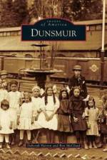
    In the 1880s, the Central Pacific Railroad labored through the rugged upper Sacramento River canyon to connect California with the far northwest. Where the canyon's steep walls open up to a view of snowcapped Mount Shasta, a railroad switching yard, a depot, a roundhouse, a turntable, and repair shops were constructed. Surrounded by virgin timber, rushing waters, and dramatic geologic formations, this railhead camp--named for a Canadian collier--grew. Completion of the rail line brought commerce and growth as timber was harvested and streams were prospected for gold. Visitors were, and continue to be, drawn by the pure mountain air, scenic beauty, healing mineral waters, hunting, and world-class trout fishing. Though facing many obstacles, including storms, fires, and floods, the town thrived. Incorporated in 1909, Dunsmuir became the headquarters for the Southern Pacific Railroad's fabled Shasta Division in 1916. Today Dunsmuir is known as California's Historic Railroad Town and is recognized in the National Register of Historic Places.

  • av Margaret Laplante & Southern Oregon Historical Society
    359,-

    It was the winter of 1851-1852 when the word "gold" echoed throughout the valley. Soon hundreds of gold miners flocked to Table Rock City, later renamed Jacksonville. In short order, families arrived and took out donation land claims and began farming, raising stock, and opening businesses. Many had already emmigrated from Europe, Canada, Ireland, and England. Jacksonville had its own Chinatown that was home to the many Chinese who had traveled far seeking their fortune through gold mining. When the railroad bypassed Jacksonville in 1883 in favor of the new town of Middleford, later renamed Medford, Jacksonville's fortunes reversed. During the ensuing decades, the town's buildings fell into disrepair. The threat of bulldozers leveling the downtown core in the late 1960s brought out a renewed interest in preservation. Today Jacksonville is a National Historic Landmark District and looks much as it did 150 years ago.

Gör som tusentals andra bokälskare

Prenumerera på vårt nyhetsbrev för att få fantastiska erbjudanden och inspiration för din nästa läsning.